
IS01:Operation Headcount
How Many Islands Are in the World?A short investigation into a number that looks objective and isn’t.

C.Y.Lu | Island Vantage | IS01
Last winter, on a night when the air smelled of old wood and damp wool, my eleven-year-old daughter looked up from her book and asked, with the casual confidence of someone who assumes the answer is in a drawer somewhere: “Dad, how many islands are there in the world?”
I reached for my phone, expecting a number. What I got, instead, was a small pile of numbers — each from a serious-looking source, none of them in the same county. The first said 2,805. The second said 340,000. The third said 782,853. They were not estimates of different things; they were estimates of the same thing.
I told her I would get back to her. She gave me the look children give parents who have just admitted they don’t know something simple. It is a look that means: I will check on you tomorrow.
Counting islands looks, on the surface, like the kind of task a careful person could do in an afternoon. The world has a finite number of them; they don’t move around much; we have satellites. Yet the three most authoritative answers — from Natural Earth, the United States Geological Survey, and OpenStreetMap — disagree by a factor of two hundred and seventy-nine.
That is not the kind of disagreement you can blame on rounding. The difference between 2,805 and 782,853 is the difference between a small town and a megacity. If three economists handed you GDP estimates that differed by 279×, you would suspect at least one of them was lying. But none of these databases is lying. They are doing exactly what they were designed to do. The trick is that they were designed to do different things.
The number that comes back depends on a question nobody asked out loud: “what counts as an island?” The map is not measuring the world. It is measuring a definition.
Pulling the three databases side by side, the gap stops looking like a mystery and starts looking like a price tag. Each database has a cost function it is silently optimising for, and the count is the receipt.
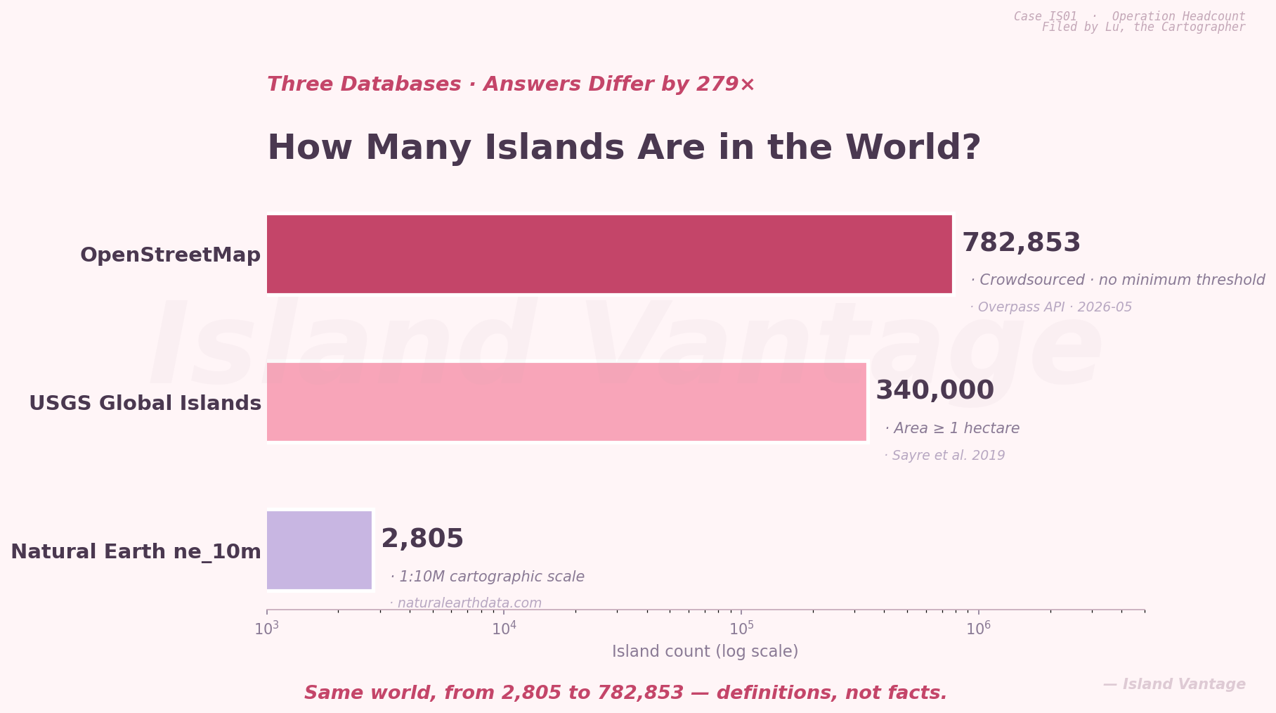
Figure 1 — Three databases, three definitions of “island.” The same world, measured against three different cost structures, returns three answers off by 279×.
Natural Earth’s 2,805 is a cartographer’s budget. It is built for printing on a 1:10-million-scale map, where anything smaller than a pencil dot is dropped on principle. The threshold is not a claim about reality; it is a claim about the page.
The USGS Global Islands database raises the bar to one hectare and returns roughly 340,000. This is the number a geographer reaches for when she has to defend her dataset to a peer reviewer. It is bigger than what cartographers will print and smaller than what citizens will tag, which is exactly the position a scholarly body wants to occupy: defensible at both ends.
OpenStreetMap returns 782,853. There is no minimum size. There is, effectively, no editor. If a person with a GPS unit decides that a rock-sized object in a Norwegian fjord is an island, then it is an island, and stays one until somebody else cares enough to remove it. Most people don’t. Crowdsourced data carries crowd enthusiasm: where amateurs spend their weekends, the count is high; where they don’t, the count is low.
You can see the asymmetry sharply if you zoom in on a single archipelago. Indonesia is a useful test case because it is, by any metric, made of islands.
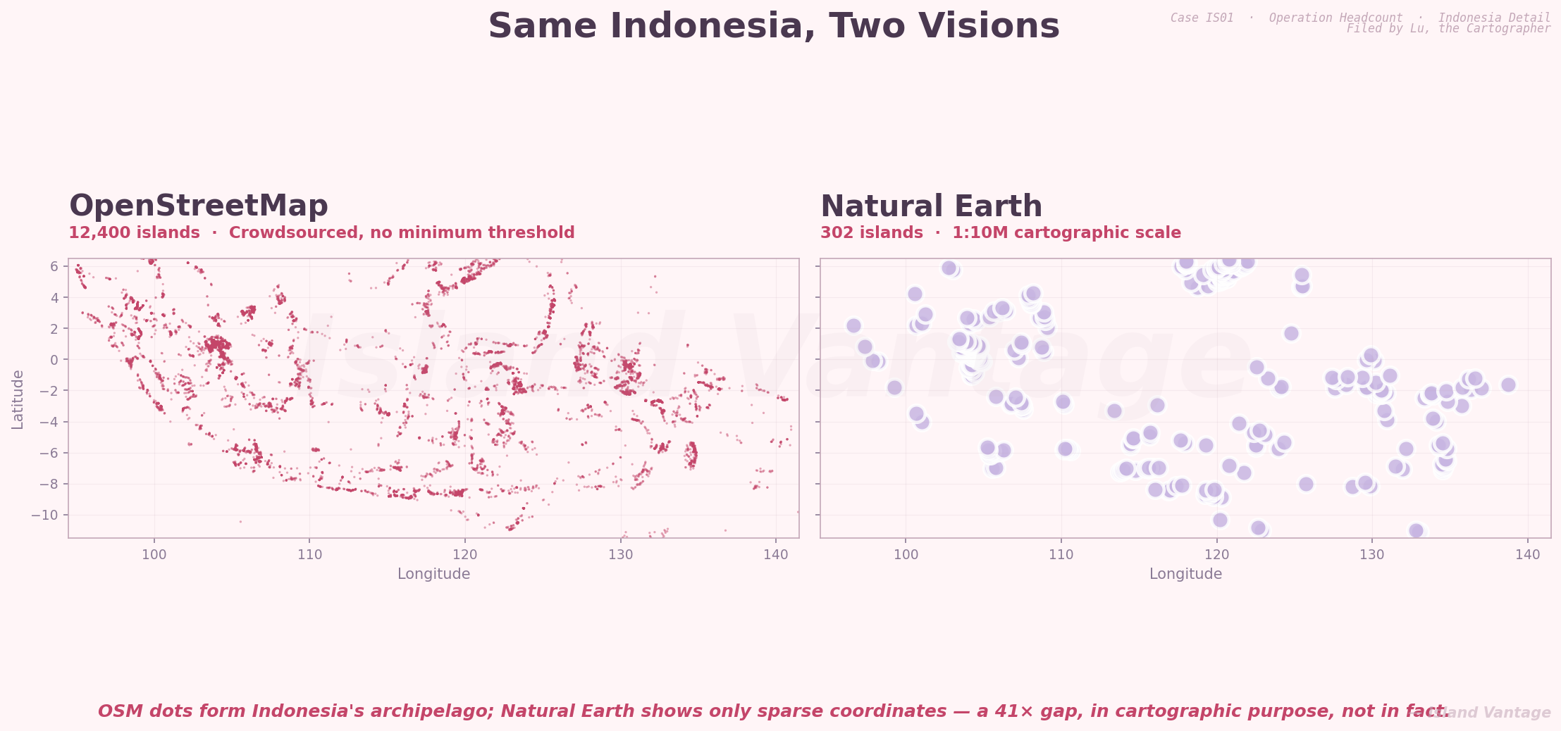
Figure 2 — Indonesia, drawn by two databases. OpenStreetMap returns more than twelve thousand points; Natural Earth returns three hundred. The shape of the archipelago disappears in one and emerges in the other.
OpenStreetMap renders Indonesia as a smear of pink dots so dense it starts to look like a coastline. Natural Earth renders the same archipelago as a constellation — a few dozen lavender points floating in the void. There is no factual disagreement between the two maps. The Banda Sea has not migrated. What differs is who the map is for: the OSM dot is a hiker’s GPS ping, the NE dot is an atlas production decision.
There is a useful word for this in economics: it is a principal-agent problem dressed up in a lab coat. The principal (the citizen who wants to know how many islands are in the world) hires an agent (a database) to count for her. The agent’s incentives — page space, peer review, weekend mapping hobbies — are not the same as the principal’s. The principal gets a number. The number reflects the agent’s job, not the world.
The temptation, having seen all this, is to ask which of the three numbers is correct. It is the wrong question. Each is correct for the job it was hired to do. If you are printing a wall map, 2,805 is the honest answer; anything more would clutter the page. If you are modelling biodiversity in coastal ecosystems, 340,000 is the honest answer; anything less would amputate the long tail. If you are writing maritime law, you probably want a fourth number nobody has computed yet, because legal islands have to sustain human habitation, and most of the 782,853 OSM rocks would not pass that bar.
The deepest insight here is not that databases disagree. It is that the word “island” carries no obligation to mean the same thing in two consecutive sentences. We borrow it freely from cartographers, from geographers, from sailors, from poets, and we are surprised when the numbers don’t add up. They were never going to.
I went back to my daughter the next morning and told her there were, depending on whom you asked, somewhere between three thousand and eight hundred thousand islands in the world. She thought about this for a while, then said, “So the answer is: it depends on the map.”
Yes. It almost always is.
— C.Y. Lu · Island Vantage · IS01
Filed by Lu, the Cartographer